



Geophysics in Nigerian Groundwater Studies
Geophysics plays a crucial role in Nigerian groundwater studies.
It provides valuable insights into subsurface conditions.
Therefore, understanding geophysics supports effective groundwater management and sustainable development in Nigeria.
Overview of Nigerian Groundwater Resources
Nigeria has abundant groundwater resources.
These resources help meet domestic, agricultural, and industrial water needs.
Groundwater remains a major water source across many parts of the country.
Groundwater Availability and Usage in Nigeria
The Federal Ministry of Water Resources estimates Nigeria’s groundwater reserves at 30 billion cubic meters.
Groundwater supplies about 70 percent of Nigeria’s total water supply.
More than 100 million Nigerians depend on groundwater for their daily water needs.
Challenges Affecting Groundwater Management and Access
Several challenges complicate groundwater management and access in Nigeria.
These challenges affect infrastructure, water quality, resource levels, regulation, and reliability.
Sustainable management requires effective policies, infrastructure investment, and public awareness.
- Many communities lack groundwater infrastructure, including boreholes and wells, which limits access to clean water.
- Industrial activities, improper waste disposal, and agricultural runoff threaten groundwater quality.
- Rapid population growth and urbanization encourage over-extraction, depleting groundwater in some areas.
- Weak regulation permits unsustainable use and water-quality degradation.
- Climate change brings prolonged droughts and erratic rainfall, threatening groundwater availability and reliability.
Protecting this valuable resource requires coordinated action across affected communities and institutions.
Geophysics for Groundwater Exploration
Geophysics provides valuable information about subsurface conditions during groundwater exploration.
It uses physical properties of rocks and soils to identify groundwater characteristics.
Furthermore, geophysical methods help locate potential groundwater zones and estimate aquifer parameters.
They can also indicate groundwater quality through variations in subsurface properties.
These methods often provide rapid, cost-effective, and non-invasive alternatives to extensive drilling.
For example, geophysicists analyze electrical conductivity, density, and seismic velocity variations.
Such analyses reveal fractures, faults, and permeability changes that influence groundwater movement.
In addition, instruments can create detailed images of subsurface formations and possible aquifers.
Researchers integrate geophysical results with geological information to develop three-dimensional subsurface models.
These models support groundwater management and sustainable water-resource development.
Geophysical Techniques Used in Nigerian Groundwater Studies
Nigerian groundwater studies commonly combine several geophysical techniques.
Each technique responds to different subsurface properties and investigation depths.
Therefore, combining methods improves the interpretation of potential aquifers and groundwater-bearing structures.
- Electrical Resistivity Tomography maps resistivity variations that may indicate groundwater zones.
- Seismic Reflection identifies faults and fractures that can control groundwater movement.
- Ground-Penetrating Radar detects shallow groundwater and images buried channels or aquifers.
- Gravity Surveys map density variations associated with geological formations that host groundwater.
- Magnetotellurics images deep groundwater reservoirs and related geological structures.
Together, these techniques help identify potential aquifers across Nigeria.
They also support sustainable groundwater management and improved water-resource planning.
Explore Further: Importance of Bioinformatics in Nigerian Public Health
Benefits of Using Geophysics in Groundwater Studies
Geophysical surveys improve how researchers assess underground water resources.
They also support faster planning while limiting unnecessary ground disturbance.
Consequently, teams can evaluate broader areas before selecting further investigation sites.
- Geophysics improves accuracy when mapping underground water resources.
- It costs less than many traditional drilling approaches.
- The non-invasive method minimizes environmental impacts.
- It provides timely data for quicker decision-making.
- Survey teams can cover large areas within a short period.
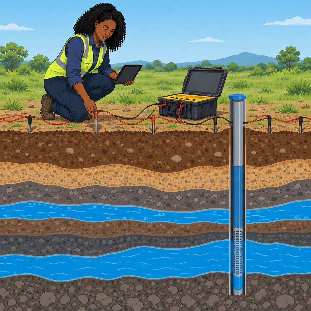
Advantages of Geophysics for Groundwater Exploration
Geophysical methods reveal subsurface structures without requiring immediate drilling.
They help investigators assess possible water sources before drilling begins.
As a result, exploration teams can make more informed groundwater decisions.
- Geophysics detects subsurface structures without drilling.
- It identifies potential water sources before drilling starts.
- The approach reduces the risk of dry or low-yielding wells.
- It minimizes guesswork and improves exploration success rates.
- Geophysics strengthens understanding of hydrogeological conditions.
Applications of Geophysics in Nigerian Groundwater Studies
Researchers have applied geophysical techniques across several Nigerian groundwater settings.
These applications examine aquifers, geological structures, water storage, and recharge patterns.
Moreover, the methods support groundwater assessment in both inland and coastal regions.
- Geophysics maps aquifer systems in the Chad Basin.
- It delineates saltwater intrusion in coastal areas.
- Surveys identify fault zones that affect groundwater flow.
- They characterize rock formations with potential water storage capacity.
- Geophysical monitoring tracks groundwater recharge across different regions.
Uncover the Details: Geology and Disaster Management in Nigeria
Challenges and Limitations of Geophysics in Nigerian Groundwater Studies
Geophysical groundwater studies in Nigeria face several technical and interpretive challenges.
Transform Your Career with Expert Guidance
Get personalized mentorship consulting that’s tailored to your unique path. Our expert advice is actionable and exclusive.
Get StartedResearchers must address these obstacles to improve survey effectiveness and groundwater investigation outcomes.
Careful planning can strengthen geophysical interpretations and support more reliable groundwater assessments.
- Diverse geological formations complicate accurate interpretation of geophysical data.
- Hydrogeological variations can reduce the reliability of geophysical imaging techniques.
- Some geophysical methods provide insufficient resolution for detailed groundwater characterization.
- Limited penetration depth restricts the application of certain geophysical techniques.
- Data interpretation requires expertise and may involve subjectivity or errors.
Strategies for Improving Geophysical Groundwater Studies
Researchers can combine multiple geophysical techniques to develop a more comprehensive subsurface understanding.
Borehole information can help calibrate geophysical results and improve interpretation accuracy.
Training and collaboration can strengthen data analysis and connect geophysical findings with hydrogeological information.
- Combine multiple geophysical techniques to improve subsurface characterization.
- Calibrate geophysical results with borehole data to strengthen interpretation accuracy.
- Apply advanced processing and inversion techniques to improve resolution and reliability.
- Provide training programs to develop stronger geophysical interpretation skills.
- Collaborate with hydrogeologists to integrate geophysical and hydrological information.
See Related Content: Challenges Facing Bioinformatics in Nigeria
Case Studies of Geophysical Surveys in Nigerian Groundwater Studies
- Geophysical methods, such as electrical resistivity imaging, support successful groundwater studies.
- For example, seismic refraction surveys assess aquifer properties and related subsurface conditions.
- These surveys identify potential groundwater resources and map important subsurface structures.
- Additionally, ground-penetrating radar delineates groundwater contaminant plumes in Nigeria.
- Consequently, geophysical surveys clarify subsurface characteristics and groundwater flow patterns.
Impact of Geophysical Surveys on Groundwater Management and Sustainability
- Geophysical surveys support sustainable groundwater management in Nigeria.
- By mapping aquifer properties accurately, geophysicists improve groundwater management and conservation.
- Furthermore, survey information guides sustainable groundwater management decisions.
- These surveys help communities locate new groundwater sources for clean water.
- Thus, geophysics strengthens groundwater conservation and management practices in Nigeria.
Delve into the Subject: Anthropology Conferences and Workshops in Nigeria
Future Directions for Geophysical Groundwater Research
Geophysics helps researchers map groundwater distribution and understand aquifer characteristics in Nigeria.
Furthermore, this knowledge supports sustainable water supply and improved groundwater management practices.
Therefore, continued research and application can strengthen groundwater exploration across Nigeria.
Additional Resources
Google search results for Role of Geophysics in Nigerian Groundwater Studies Sciences
Bing search results for Role of Geophysics in Nigerian Groundwater Studies Sciences


