




Geophysical Data Interpretation in Nigeria
In Nigeria, geophysical data interpretation techniques support several important industries.
These industries include oil and gas exploration, mining, and environmental studies.
Moreover, these techniques help professionals discover oil and gas deposits, minerals, and water sources.
Therefore, they support resource development and environmental management.
In the oil and gas industry, specialists use these techniques to map subsurface structures.
They also identify potential drilling sites and assess reservoir properties.
This information guides decisions during exploration and production activities.
Likewise, mining professionals use interpretation techniques to locate mineral deposits.
They determine deposit size and depth before planning extraction operations.
As a result, companies can improve mineral resource utilization and optimize mining processes.
Environmental researchers apply these techniques to assess human impacts on the environment.
They also monitor natural disasters and evaluate ecosystem health.
By analyzing geophysical data, researchers can identify potential environmental risks.
Consequently, they can develop strategies for mitigation and conservation.
These applications help industries make informed decisions and minimize operational risks.
Ultimately, geophysical interpretation supports sustainable development in Nigeria.
Geophysical Data Interpretation Techniques
- Geophysical data interpretation techniques analyze and process measurements to extract valuable subsurface information.
- Meanwhile, Nigerian practitioners commonly use seismic, gravity, magnetic, electromagnetic, and well log data.
- These techniques support decision-making across oil and gas exploration, mining, and environmental studies.
Importance of Geophysical Data Interpretation
- Geophysical interpretation helps specialists identify subsurface structures, geological formations, and potential hydrocarbon reservoirs.
- Furthermore, professionals use interpreted data to select suitable locations for drilling wells or conducting mining operations.
- Interpretation also helps teams assess project viability, reduce risks, and improve resource utilization.
- As a result, accurate interpretations support informed decisions, cost savings, and improved operational efficiency.
Techniques Used in Geophysical Data Interpretation
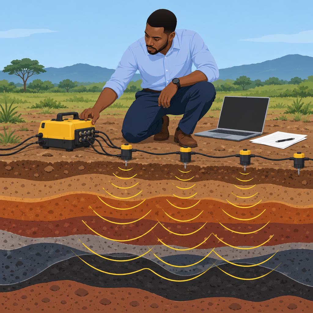
- Seismic interpreters analyze reflected and refracted waves to create images of subsurface rock layers and structures.
- Gravity and magnetic methods map field variations to reveal anomalies and geological features.
- Electromagnetic methods detect conductive materials and map subsurface resistivity variations across geological settings.
- Well log interpretation evaluates lithology, porosity, fluid content, and other reservoir characteristics from borehole data.
Challenges Affecting Geophysical Data Interpretation
- Complex geological settings, limited coverage, and poor quality can complicate geophysical interpretation in Nigeria.
- Moreover, cultural and language differences can hinder communication among multidisciplinary project teams.
- Insufficient training and expertise may produce inaccurate interpretations and poorly informed decisions.
- Finally, integrating multiple survey datasets can consume time and require sophisticated software tools.
Future Directions in Geophysical Data Interpretation
- Machine learning and artificial intelligence algorithms increasingly transform geophysical data interpretation processes.
- In addition, automated workflows and predictive modeling tools improve interpretation accuracy and analytical efficiency.
- Integrating geophysical and geospatial datasets enables more comprehensive interpretations for decision-making.
- Continued research advances data acquisition, processing, imaging, and interpretation methodologies.
Common Geophysical Methods Used in Nigeria
Investigators choose geophysical methods according to investigation objectives.
Subsurface materials also influence the suitability of each method.
Each method offers distinct strengths and limitations for interpreting geophysical data.
Seismic Method
The seismic method sends sound waves into the ground.
It measures returning echoes to identify potential subsurface reservoirs.
Additionally, it produces detailed subsurface images but costs more and may disrupt the environment.
Magnetic Method
The magnetic method measures variations in Earth’s magnetic field.
These variations help identify subsurface structures during mineral exploration.
However, magnetic interference can limit its ability to detect shallow buried objects.
Gravity Method
The gravity method measures gravitational variations caused by subsurface density differences.
Researchers use it during geological and geotechnical investigations.
It operates non-invasively and reveals density information, although it provides lower resolution than some methods.
Electromagnetic Method
The electromagnetic method uses electromagnetic fields to detect conductive subsurface materials.
It supports mineral exploration and environmental studies.
Moreover, it can detect groundwater resources, but depth penetration and cultural noise limit results.
Investigators should match each method to the investigation objectives and subsurface conditions.
Careful consideration of strengths and limitations supports accurate interpretation of geophysical data.
Gain More Insights: Professional Bodies for Biochemists in Nigeria
Challenges in Geophysical Data Interpretation in Nigeria
Interpreting geophysical data in Nigeria creates several professional challenges.
Professionals must navigate issues involving data quality, equipment, expertise, and interpretation complexity.
These challenges can affect the accuracy and reliability of geophysical interpretations.
- Environmental noise and equipment limitations can reduce data reliability and accuracy.
- Limited access to advanced equipment can affect the quality of collected data.
- A shortage of trained professionals can hinder accurate geophysical data analysis.
- Specialized knowledge remains necessary for interpreting complex geophysical information.
Issues Related to Data Quality
Several factors can reduce the quality of geophysical data collected in Nigeria.
Environmental interference, calibration problems, and processing errors can distort measurements.
Consequently, inaccurate data can produce misleading interpretations of subsurface conditions.
Transform Your Career with Expert Guidance
Get personalized mentorship consulting that’s tailored to your unique path. Our expert advice is actionable and exclusive.
Get Started- Human activities and geological features can introduce noise into geophysical readings.
- Inaccurate equipment calibration can create errors during data collection and interpretation.
- Processing mistakes can produce misleading geophysical interpretations.
Equipment Availability Concerns
Advanced geophysical equipment remains difficult for many organizations to obtain.
High procurement and maintenance costs restrict access to modern instruments.
Furthermore, limited suppliers and obsolete technology can delay or weaken geophysical investigations.
- High equipment costs limit access for many organizations.
- Few regional suppliers can cause procurement delays and equipment shortages.
- Outdated technology may provide inaccurate or unreliable geophysical data.
Expertise and Knowledge Transfer Issues
Nigeria faces a shortage of professionals skilled in geophysical data interpretation.
Limited training opportunities can reduce the number of qualified geophysical data analysts.
Brain drain and weak knowledge transfer can further reduce local expertise.
- Limited training programs restrict the development of qualified interpretation specialists.
- Skilled professionals may seek opportunities abroad, creating domestic expertise gaps.
- Professional turnover can limit mentorship and knowledge transfer to newer specialists.
Strategies for Improving Geophysical Data Interpretation
Stakeholders can address these challenges through coordinated investment and professional development.
Training, collaboration, technology upgrades, and government support can strengthen local capabilities.
Clear standards can also improve the quality and consistency of geophysical interpretations.
- Expand education and training programs for geophysical data interpretation.
- Collaborate with international experts to transfer knowledge and professional practices.
- Upgrade equipment and technology for more accurate data collection and interpretation.
- Provide government funding and incentives for research and development.
- Establish regulations and standards for geophysical data quality and interpretation.
These measures can help Nigeria strengthen geophysical data interpretation and address persistent professional obstacles.
Discover More: Impact of Agricultural Economics on Nigeria's Economy
Successful Geophysical Data Interpretation Projects in Nigeria
Geophysical interpretation projects have supported oil exploration, mineral prospecting, and groundwater assessment in Nigeria.
These projects applied different methods to identify valuable subsurface resources.
Despite technical challenges, the reported outcomes supported industrial and community development.
Seismic Interpretation for Oil Exploration
A successful Nigerian project interpreted seismic data to support oil exploration.
Specialists processed seismic measurements to identify potential oil reservoirs.
However, complex geological structures and limited data created significant interpretation challenges.
- The project discovered a new oil field with high production potential.
- It increased investment and production within Nigeria’s oil industry.
Magnetic and Gravity Interpretation for Mineral Exploration
Another successful project interpreted magnetic and gravity data for mineral exploration.
Researchers processed and integrated both datasets to identify potential mineral deposits.
Nevertheless, cultural noise required advanced techniques for accurate data analysis.
- The project identified new mineral prospects and encouraged increased mining activities.
- It attracted foreign investors and supported Nigeria’s economic growth.
Electrical Resistivity Interpretation for Groundwater Exploration
A third project used electrical resistivity interpretation for groundwater exploration.
Analysts examined resistivity data to delineate aquifers and assess groundwater quality.
Subsurface heterogeneity and calibration requirements complicated the interpretation process.
- The project located new groundwater sources for local communities and agriculture.
- It improved access to clean and reliable water supplies.
Benefits Across Nigerian Industries
These case studies demonstrate geophysical interpretation’s applications across several Nigerian resource sectors.
Oil exploration, mineral prospecting, and groundwater assessment each benefited from specialized interpretation methods.
The projects converted subsurface information into outcomes supporting investment, production, mining, agriculture, and water access.
- Geophysical interpretation helps unlock Nigeria’s natural resource potential.
Learn More: Geology vs. Environmental Science: Choosing Your Path in Nigerian Sciences
Advances in Geophysical Data Interpretation
Recent advances in geophysical data interpretation have transformed how professionals extract information from subsurface data.
Advanced software and hardware now improve interpretation accuracy and efficiency.
Moreover, machine learning and artificial intelligence strengthen the interpretation process.
Machine learning algorithms examine large datasets and identify patterns human analysts may overlook.
Consequently, analysts produce more precise interpretations and reduce errors in geophysical studies.
Three-dimensional modeling and visualization tools also clarify subsurface structures.
These tools create detailed models that simulate real-world conditions and support decision-making.
Drones and remote sensing technologies improve data collection in inaccessible or hazardous areas.
Drones gather high-resolution aerial imagery and geophysical data for interpretation.
Future Trends in Geophysical Interpretation
Looking ahead, future interpretation techniques show strong promise.
Advancing sensor technologies and data processing algorithms will expand geophysical exploration capabilities.
Furthermore, integrating geophysical, geological, and geochemical datasets will clarify subsurface characteristics.
Real-time interpretation tools will help geoscientists make rapid, informed field decisions.
Additionally, machine learning within these systems will improve analytical speed and accuracy.
In Nigeria, continued development of these techniques reflects the industry’s commitment to innovation and excellence.
Gain More Insights: Fieldwork Experiences in Animal Science Education
Training and Capacity Building in Geophysical Data Interpretation
Professionals in Nigeria can strengthen their geophysical data interpretation skills through focused training.
Furthermore, capacity building helps geoscientists apply their knowledge with greater confidence.
Continuous development also supports informed decisions when professionals interpret complex geophysical data.
Importance of Training and Capacity Building
Effective training improves technical performance and supports accurate interpretation of geophysical data.
Moreover, capacity building helps professionals strengthen their analytical and problem-solving abilities.
These benefits can improve professional confidence and encourage reliable interpretations.
- Training improves technical proficiency in interpreting geophysical data accurately.
- It helps geoscientists stay updated with current trends and technologies.
- Regular learning strengthens problem-solving abilities and critical thinking skills.
- Professional development supports career advancement and expands job opportunities.
- Skilled professionals produce higher-quality and more reliable interpretations.
Continuous Education and Professional Development
Geophysical interpretation techniques continue to evolve, so professionals must maintain current knowledge.
Additionally, regular education helps geoscientists adapt to changing software tools and methodologies.
Professional development also encourages collaboration across multidisciplinary teams.
- Evolving interpretation techniques require professionals to monitor changes in the field.
- Regular training helps geoscientists adapt to new software tools and methodologies.
- Continuous education encourages innovation when professionals interpret complex data.
- Professional development improves collaboration within multidisciplinary teams.
- Ongoing learning keeps professionals informed about best practices and industry standards.
Ways to Enhance Interpretation Skills and Expertise
Professionals can develop their expertise through structured learning and practical experience.
Similarly, professional networks provide opportunities to exchange knowledge and insights.
Mentorship can also guide geoscientists as they improve their interpretation abilities.
- Professionals can attend workshops, seminars, and conferences about geophysical data interpretation.
- Hands-on exercises allow geoscientists to practise interpreting real-world geophysical datasets.
- Advanced degrees or certifications can deepen knowledge of geophysics and related fields.
- Experienced geoscientists can provide mentorship, guidance, and valuable professional insights.
- Professional organizations and networks help peers connect and share knowledge.
By investing in training, professionals in Nigeria can sharpen their skills and remain competitive.
Consequently, stronger expertise can support the continued advancement of geophysical data interpretation.
Strategic Value of Geophysical Interpretation in Nigeria
Geophysical interpretation can support informed decisions about Nigeria’s geological resources.
It can also guide responsible planning across economic and environmental priorities.
Moreover, seismic imaging and electromagnetic surveys can strengthen subsurface evaluations when professionals apply them appropriately.
Continued research and innovation can improve resource management strategies in Nigeria.
Furthermore, investment in technology and skills can help practitioners maximize available geophysical information.
These efforts can promote sustainable development while supporting efficient resource utilization.
Therefore, coordinated action can strengthen geophysical interpretation’s contribution to Nigeria’s future.
This approach can benefit Nigeria and its people.
Additional Resources
Google search results for Geophysical Data Interpretation Techniques in Nigeria Sciences
Bing search results for Geophysical Data Interpretation Techniques in Nigeria Sciences


